Bude, Cornwall to Crackington Haven, Cornwall
A easier walk than the last section, 8 miles from Bude to Crackington
Haven
- mile 8 - 10
- This section is along the cliffs for two miles, past the
Coast Guard lookout and a navigation marker, until you meet the road, and
the path follows the road for a mile or more, until you drop down to Widemouth
Sands
 |
 |
 |
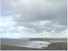
| Approaching Widemouth Bay |
Leaving Widemouth |
The view north past Widemouth |
- mile 10-12
- You can either walk along the long, wide, sandy beach
at Widemouth Bay, or along the top of a low cliff past the Old Salthouse Cottage.
 |
|
 |
| Millook Haven |
|
Folded Cliffs |
- mile 12-14
- You climb up out of Widemouth Bay, and back to the rugged
Cornish scenery again, descending to the sea again at Millook Haven. Here
again there are fantastic Cliffs with layers of folded rock showing the sort
of torment that the strata here underwent.
- As the paths goes on south, it passes a wood of stunted Sessile
Oaks, by a steep coombe. This is the only surviving Cornish oak wood. Gales
and wood cutters got the rest
- The section ends with two mote steep coombes to go down and
up
- mile 14 - 16
- There is now only one steep coombe between you and Crackington
Haven. The cliff path follows the tops of high cliffs (reaching to 430 feet)
with there striking folded rock strata.
- The path rounds the 400 foot Pencarrow Point, then drops
down into Crackington Haven. This is a surfing beach, with a small gaggle
of houses, a shop and a pub, the Coombe Barton.
 |
|
 |
| The pub at Crackington Haven |
|
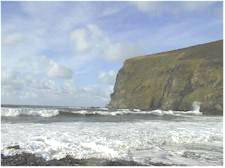
Surf at Crackington Haven |
And if you want to learn more about Cornwall,
then try our Cornish information site, Cornwall Calling
Cornwall Coast - your guide to the Cornish Coastal
Path
